CASTLEWELLAN UNDERWAY....

Yes, it's true, the construction of the trails at Castlewellan is finally underway.

Whilst trail building at Rostrevor is all about working in the middle of nowhere on top of a mountain with lots of peat, rocks and water, Castlewellan is a whole different ball of wax.

Castlewellan Forest Park has been managed with landscaping and biodiversity in mind for generations and these trails have to take that into account.

The Euroservices guys are doing a fantastic job on Section 18 at Castlewellan, where the landscaping of the trails is so important.

But the crucial thing is that the trail planning and design process that we used at Castlewellan has allowed for all of these issues to be taken into consideration and built into the construction process from the start. This means that Euroservices are able to get it right first time - just take a look at the photos below to decide for yourself if this is the case.


ROSTREVOR - SLINKY DINKY DOO!!


Section 13 of the Rostrevor Mountain Bike trails has taken shape since the helicopter lift of stone the other week.

The picture below shows what little impact the trail has had on the open mountain even though it has only just been built.


CASTLEWARD REVISITED


Went to Castleward for a bit of a look around again the other day, just to check out some of the trails I missed last time I was over there. 

I’m so pleased with the way these trails look, they have really matured into the landscape in a very short time and I think they really add something to the estate. I was particularly pleased with the trails in Tullyratty which is an ASSI for its species rich grassland and where I reckon there has been no net habitat loss due to the trails. Instead the trails allow people to access this very special habitat in a sustainable way which might just increases people’s awareness of it and change how they value it. The trails in Mountain Wood looked great too as did the old forest road which was changed into a twisty singletrack with landscaping and demarcation and the clear felled areas have greened up nicely.

All in all I am very pleased with these trails. They were never intended to be ‘mountain bike trails’ for people on bouncy bikes, rather they were intended to be a network of multi use trails built around a hierarchy of access.  The all ability trails provide access to the foreshore for all kinds of user, whilst the wider trail network allows for walkers, runners, cyclists and horse riders to enjoy this very special Estate.


The above picture shows the forest road that was turned into a nice twisty singletrack to reduce the gradient – pretty easy to do but really worthwhile I think. 


This the equestrian trail through the specials rich grassland – really careful design and detailed construction specifications allowed this trail to be put into this very sensitive habitat with minimal disturbance. 


This picture shows the walking and cycling trail through the species rich grassland. Very carefully landscaped demarcation on both sides of the trail has helped reduce the impact of the trail and its users on the ASSI. The landscaping has effectively led to the demarcation disappearing into the landscape.


Dafydd Davis
27/09/12

THUNDERBIRDS ARE GO .......

The Irish helicopter boys arrived on site at Rostrevor last week and have been making light work of moving the stone out onto Section 13 across the Slinky and up onto Section 10.

Check out the videos below for a close up!!


READY FOR LIFT OFF............

The pictures below show bags of stone at Rostrevor ready to be airlifted into Section 13 on the slopes of Slieve Meel.

This is an exciting, but also slightly apprehensive time for everyone involved with the Rostrevor project.

Hopefully, Euro Services will perfect their airlifting methods, which can greatly facilitate the process of building trails in difficult and inaccessible places.


RECREATIONAL TRAILS AND LAND USE

The fear that many land owners have when considering developing recreational trails is the impact this will have on the commercial viability of their current land use e.g. forestry, grazing, water catchment etc.

Whilst these fears are understandable, with the right approach it is more than possible to develop trails with minimal impact on land use, and where land use has minimal impact on the trails. This is something which is a major part of our 'Sustainability Framework', which underpins all our recreational trail designs.

The key is to start out by creating a frame of reference with land owners and managers which will guide the rest of the project and will establish issues such as aims and objectives, the status of any trail development, current land use and recreational use etc. 

In a great deal of cases official trail development takes place to manage unsanctioned recreation on land, which is impacting upon land use, the aim being to resolve these issues. For example, when considering unsanctioned trails in a commercial forestry setting, it is very difficult for foresters to predict the flow of recreational users when the trails are unsanctioned and as forestry can present a hazard to the public, this can affect the liability of the land owners and managers in terms of reducing risk to the public. 

When official trails are put in place, it is much easier to manage the flow of users and to establish diversions and trail closures for the time required for forestry operations. In addition, the trails are protected by their official status - when harvesting takes place, measures are taken to protect any parts of the trails which could be impacted upon, and during the design process, measures are taken to ensure the sustainability of these trails in every sense e.g. raised trails structures placed on top of the land will be greatly impacted upon, whereas it is much less likely that an effective bench cut, designed with harvesting in mind will be damaged.

The same is true for any type of property or land use. Establishing the Frame of Reference on an individual basis for each project is wholly important, there is no such thing as successful trails when taking a 'cookie cutter' approach - each property and its issues are different.

So once again, the point is this - a prescriptive and considered approach to trail development set within the context of a Frame of Reference agreed upon by stakeholders is the way to go about getting THE RIGHT TRAILS, IN THE RIGHT PLACES, IN THE RIGHT WAY.


THE MOURNES - THE MOUNTAIN BIKERS ARE COMING!!!!


The opening of the new 'Mournes Mountain Bike Trails' at Rostrevor and Castlewellan in Spring 2013 is already a much talked about topic. With hundreds of riders already chomping at the bit to get out there (and thanks to all the guys and girls who are being respectful and keeping off the trails whilst under construction) the opening will bring a whole new market to the area which will need to be catered for if the local economy is to benefit to its maximum potential – and the impact could be potentially huge.

A quiet day at Coed y Brenin

Take for example the original trail centre – Coed y Brenin in North Wales. Once the centre opened, so did the floodgates. The visitor numbers to Coed y Brenin increased from around 14,000 a year to in excess of 150,000 a year in 4 years with at least 90% of new visitors being mountain bikers, and 80% of mountain bikers were weekend visitors, resulting in a £5 million a year cash injection into the local economy. 

Local businesses adapted to provide for this new market, including accommodation such as B&B’s and hotels providing secure storage for bikes and kit washing and drying services, the provision of bike hire and repair services, mountain bike shops,  trail guide services and much more.

Rostrevor and Castlewellan together will make for a great weekend’s riding in beautiful scenery and all those mountain bikers will want good grub to eat and a few pints of an evening. If the area really wants to benefit from these trails, local businesses need to be prepared to give mountain bikers the services that they need to make the Mournes a great mountain biking destination.

WEEK 16 AT ROSTREVOR

Below is a selection of pictures showing Section 19 at Rostrevor. The pictures show that it is possible to build a nice flowing trail with lots of features, without having too much impact, and by being sympathetic to the landscape and the setting. However, this could not have been achieved here without a great deal of very careful and time consuming planning and design.


The picture below is Section 20, which links into Section 19 and both sections together should provide a really fun, fast and flowing descent.


The last two pictures show Section 9, which is hidden away at the top of The Fallows. Effective planning and design has enabled a sympathetic approach to be taken to this section, whilst also taking into account very difficult and challenging ground conditions.


Mournes and Slieve Croob Strategic Path Review

In Spring 2012, ' Trails by Dafydd Davis' was employed by The Mournes Heritage Trust to produce a report named 'The Mournes and Slieve Croob Strategic Path Review', which was funded by Sport NI and NIEA. 


The process of producing this report involved very lengthy consultation with stakeholders, including land owners and managers, the Mourne Outdoor Recreation Forum, DARD, Fire Service N.I. and users of the upland paths, and the steering group consisting of Public Rights of Way Officers of local councils, representatives of Mountaineering Ireland, Outdoor Recreation NI (formerly CAAN), Sport NI, NIEA and the Mournes Heritage Trust. 

There is a vast network of paths onto the Mournes, and these were assessed individually, and as a whole, in terms of sustainability and visual and physical impact on the landscape (see trail inspection forms in the appendices to see all the elements that were evaluated), and strategic recommendations made for each. 

To read about the complex issues which surround these paths in their beautiful upland setting, click on the link below. The appendices contain the trail inspection forms, maps and photos and a whole lot more, so be sure to have a read of this also.


ROSTREVOR TAKING SHAPE ......


This is Section 20 and is part of the last leg of the cross country trail back into Kilbroney. I'm very pleased with this and it's turned out pretty much exactly as I'd envisaged it i.e. fast and flowing with lots of grade reversals and quick little turns. 


This is the same section - note the very limited impact on the ground around the trail. With needle fall and traffic this section should quite quickly start to feel quite naturalistic and that's been the aim all along.


The same section again - showing where the trail has been stone pitched over big roots to give what are almost natural rollers.


This is Section 9 up in The Fallows. The Euroservices boys have done a great job here in truly awful conditions. Winter style rainfall and saturated ground have made life very difficult for them, but their impact is still very limited. I think this trail is going to be a bit of a gem even if it is in a pretty wet and midge infested place!

Dafydd, 06/08/2012


CRAIGAVON TRAIL MAINTENANCE DAY

On Saturday 21st July 2012 a willing band of volunteers, rustled up by Kelley Rushton of Lough Neagh Discovery Centre arrived at Craigavon for a hard days graft repairing some sections of the trails. Many thanks to Rich and Davey of Trailbadger.com for the photos below and their assistance in getting more volunteers for the day, as well as rolling up their own sleeves. 


So here are some photos to prove how much can be done in such a little time - amazing work guys.

This first photo isn't actually the trail, but badly rutted ground to the left of the trail (the actual trail being hidden under the brambles to the right). 


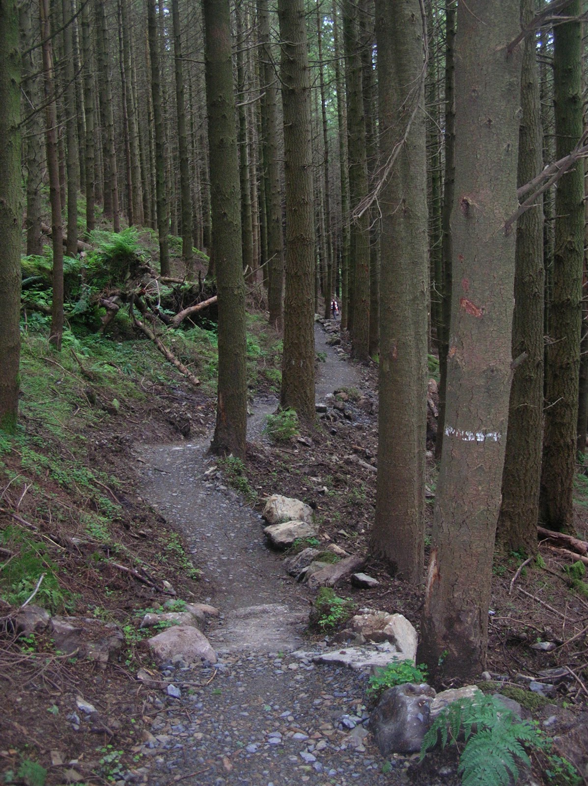
The next photo shows the same bit of trail, brambles removed, the muddy hole filled in and some good demarcation put in place. The existing trail also got a good light dressing of stone.


The next photo shows where riders have been taking short cuts to avoid a puddle and this has resulted in rutting and the retention of more water.


The guys in the photo below are busy working on the above section, concentrating on reprofiling the turn so it's a bit more insloped, surfacing and demarcating.


The next photo shows the guys whackering in sub base on the same section.


And the next shows them digging up the existing trail to reprofile.


And here's the turn almost finished....


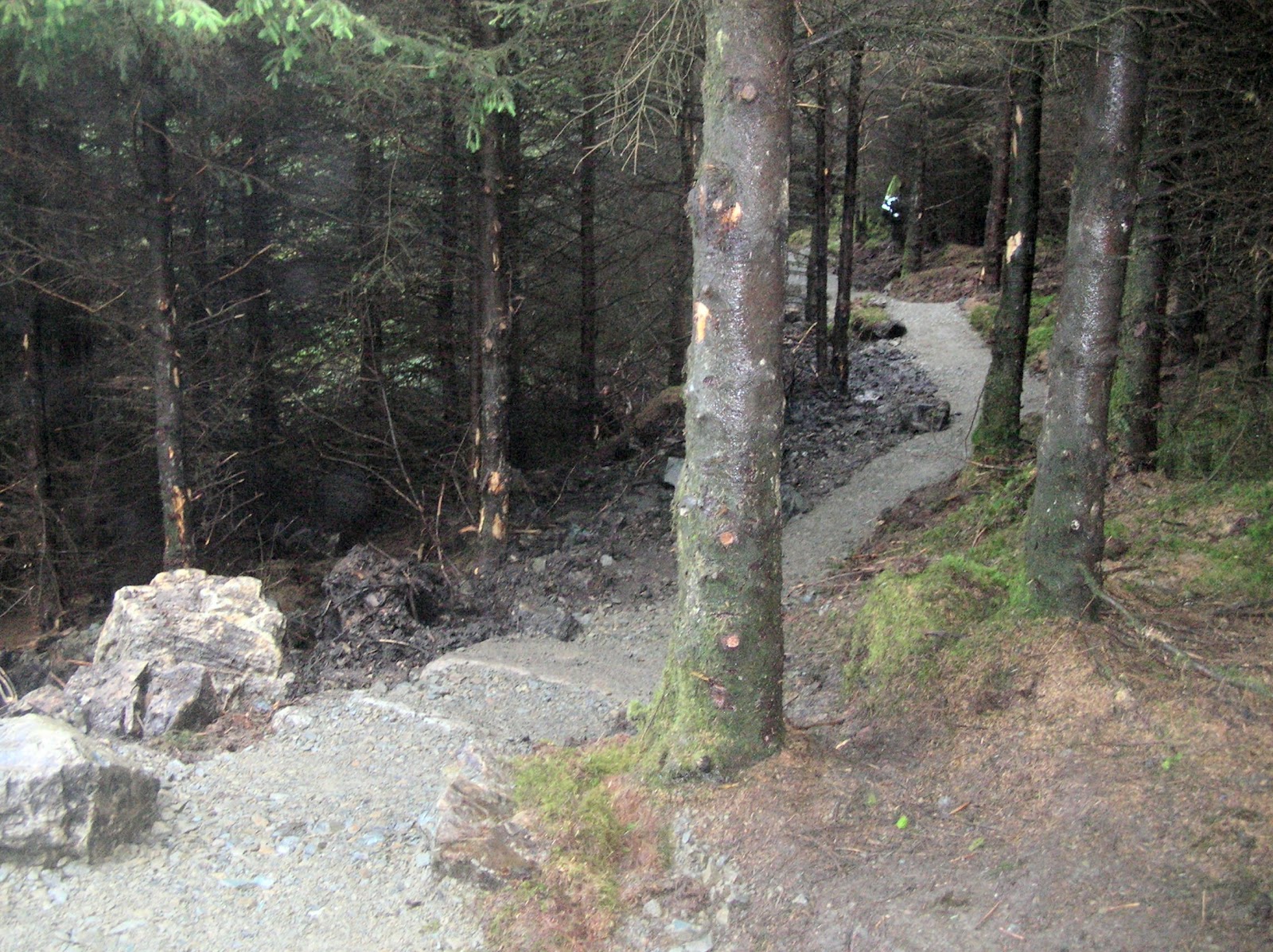
The next photo shows a badly rutted section of trail, where a lack of effective demarcation led to people riding on soft ground on either side of the hard trail surface. This led to rutting and eventually to the near collapse of the trail structure.


The next two photos show the above section repaired and with some really effective demarcation put in place to keep people on the hard trail surface. The important thing is that the demarcation be properly set into the ground and is landscaped to try and make it look as though it belongs there.


Well done to all the volunteers who turned up on the day and many thanks for all the effort. 

The Craigavon trails are a great community asset, not just for mountain bikers but for walkers and runners alike and it's great to see these sections restored to their former glory.


BALLYHOURAS

Just found some pretty cool videos of the Ballyhoura MTB trails in the Republic of Ireland on Coillte land. 

These trails were designed by Dafydd and this is the largest MTB trail network in Ireland, with over 50km of trails in a stacked loop system, with something for everyone.

Check them out :-)


WEEK 12 AT ROSTREVOR - SECTION 3 + TRAIL PLANNING AND DESIGN

Week 12 at Rostrevor and some sections are nearing completion. The pictures below show Section 3, which will be the first descending section on the big cross country loop after the long climb from Killbroney. 

This section of trail crosses a steep slope through big trees with lots of step downs, rollable sections of stone pitching and grade reversals. The idea with this section was to have as little impact on the big trees as possible and to use the existing terrain and features to create a fun descent.


The above picture shows a bit towards the bottom of Section 3 - I think it looks great and after a bit of needle fall, will look and feel pretty natural.


You can't really tell from this picture, but this actually descends at about 10% and there are loads of funky grade reversals and step downs - I'm pretty pleased with how this section fits into the landscape here.


The same bit again, check out how the trail uses the trees to demarcate the turns.


Again, it's quite difficult to see form the picture, but this one shows some of the grade reversals that characterise this section.

TRAIL PLANNING AND DESIGN


The way that the trails look in Rostrevor and how they sit in the landscape is no happy accident - rather, this is a result of a very lengthy planning and design process which took into account a lot of different issues and concerns raised by all kinds of stakeholders. The trail planning needed to take into account minimising the impact of trails on forest services' ability to carry out commercial forestry operations, whilst also making sure that the trails themselves were sustainable in the widest possible sense. 


Consultation with local residents, recreational users groups and crucially, the local mountain biking community helped develop a clear frame of reference that has guided and informed the planning and design of these trails from the start.


Lots of people love Rostrevor Forest, and it's an important local recreation and tourism asset, where people come to run, walk, ride a horse, ride a mountain bike or just have a picnic. It was very important that the development of mountain bike trails did nothing to devalue the place or undermine its importance to the local community. 


With all of this in mind the planning and design of the trails system has centered on minimising the visual and physical impacts of the trails and giving them a naturalistic feel in the hope that this will connect mountain bikers to this beautiful and very special landscape for years to come.


The time spent establishing definitive trail lines and developing very detailed prescriptive plans has enabled Euroservices to fairly and accurately price the trail construction work and for us to monitor and measure the work in a robust way. 


Dafydd Davis
24th July 2012

ROSTREVOR UPDATE

A couple more pictures from Rostrevor ....watch out for next weeks blog, which will include some pictures of Section 3, a more featured, funky section than those shown previously, with some discussion about the trail planning and design work that went into the project.


The above picture shows the turn at the top of Section 5 on the climb up to Slieve Martin.

This is a superb viewpoint out over Carlingford Lough 

(note Andy's abomination of a completely rigid single speed bike with dropped handlebars!!!??)


Above is a photo of Section 5, where it climbs across a very steep hillside through big trees - the Euroservices guys have done an amazing job with this, with very little impact on either the ground or the trees.

WESTERN AUSTRALIA

Dafydd has recently spent three weeks over in Western Australia (no...not on holiday, unfortunately for him!!)

CONFERENCE

He was a guest speaker at the IMBA conference in May, speaking about the importance of trail sustainability, trail planning and about creating a sustainability framework which all trail planning and design should work within.


See the link below (about half way down the page) to see what WAMBA had to say about Dafydd's presentation:


Beautiful blue sea of Perth - Dafydd was staying in a hotel just around the corner from here :-)


A great example of an accessible trail in a heavily used beauty spot  which as been integrated into the landscape near Albany

SUSTAINABILITY FRAMEWORK

For the rest of the time Dafydd sent in WA he was liaising with land owners/managers, statutory bodies, native heritage groups and stakeholders to develop a sustainability framework that will be used by DEC (Department of Environment and Conservation), DSR (Department of Sports and Recreation), West Cycle and WA Mountain Bike Association during the planning and design of any new trails. The first draft of this document is currently being circulated among the groups above and I'm sure there are future trips to Aus on the cards for Dafydd - lucky guy ;-)

Castle Ward Multi Purpose Trails


Dafydd revisited Castle Ward on Tuesday evening to have a look at the multi use trails that were put in just over a year ago that were designed by Dafydd.

Castleward is a very special place in landscape terms and it was very important that the trails fit in with the landscape in every sense. The trails that were put in were designed to appear like thay had always been part of the estate and are open to a range of uses including equestrains, walkers, cyclists and the less able.

He was very pleased with the trails and we think the pictures speak for themselves:


 This photo shows the multi-use trail along the property boundary. This was designed to make it invisible from particular parts of the estate and to be very soft on the landscape.


This photo shows the Category 3 trail in the Woods which has really blended in well in a very short time.

As always the key issue that underpinned Dafydd's design work here was sustainability, and a year on they have proven to be very popular with trail users and sustainable in every sense.


This Week at Rostrevor

Following another week of site supervision at Rostrevor, here are couple more photo's to keep you updated with progress at the site:


 The above photo shows Section 5 on the Rostrevor mountain bike trails. This is a long climb and has been designed to allow for a nice steady ascent.


This photo shows the same section near the Cloughmore stone in the open ground. The idea with this one is to try and minimise the visual impact in this sensitive area. Note the landscaping and trail demarcation here.

As stated previously, it is very important that no members of the public use these trails either on foot or bike before the construction of the whole trail system is completed.

We shall continue to keep you updated with progress. 
  

A glimpse of trail building and riding at Jablonec


A film by Petr Slavik featuring Dafydd Davis and the construction of a singletrack trail, Singltreku v Jablonci. Hard to work out what some of these very cheerful looking builders and riders were saying, but they do seem to be having fun!

Dafydd's thoughts on the Rostrevor Project...

Have just got this quote from Dafydd regarding the trails at Rostrevor:
“I’ve been involved in trail planning, design and construction for nearly 20 years all over the world. I’ve worked on high mountains, old quarries, city parks, deserts and even rainforests, but I think the trail construction project in Rostrevor is probably the most challenging I have worked on to date.

The combination of steep side slopes, very variable ground conditions, dense woodlands and high, exposed ridges, coupled with very difficult access makes trail construction particularly difficult.

Add to this the fact that Rostrevor is within the Mournes AONB where there are particular landscape and habitat sensitivities, further complicates how sustainable trails can be delivered.

It is really important that the trails in Rostrevor be built in appropriate and sensitive ways, which reduce their impact on the landscape and habitat. This is particularly the case given the value of Rostrevor Forest as a recreational resource for the whole community.

The development of very prescriptive construction plans has allowed us to make sure that the trails add value to Rostrevor by making sure that they are built in the most appropriate and sensitive ways.”

More ROSTREVOR PICS

This is Section 4 - which is mostly a climbing section - the guys have done a great job here and have had minimal impact, within 6 months or so, this will feel almost like a "natural" trail

This is Section 4 again - a long, steady climb - the ground here was particularly bad, either deep waterlogged peat or big rocks

This is Section 4 again - one of the short sections of slightly  descending trail - it's difficult to make out in this picture, but this trail is quite featured with little step downs and grade reversals, adding interest to what is mostly a long climb

This is the end of Section 4, where it joins the Cloughmore path -  again, a gradual climb and the Euroservices guys have done a great job of minimizing the visual and physical impact of the trail

This is the first part of Section 5 - there were initial concerns about this new trail being visually intrusive from the Cloughmore car park, however as can be seen from the picture, it's visual impact is negligible - this picture was taken not more than 4 hours after the section was started

This is Section 21 - which will be the last bit of trail leading back to the car park at the end of the big cross country loop - the idea with this section is to make a twisty low speed connection back to the car park - again Euroservices have come up trumps!!


(So where did you drop it???)

More of Section 5


IT NEEDS TO BE STRESSED THAT MEMBERS OF THE PUBLIC SHOULD NOT BE ACCESSING THE TRAILS AT ANY TIME DURING THE CONSTRUCTION PROCESS - EITHER ON FOOT OR BY BIKE